|
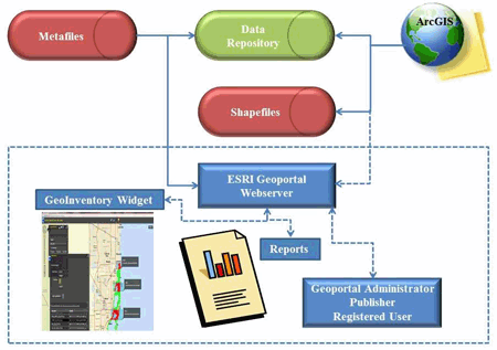
Conceptual diagram of the customized ESRI Geoportal webserver |
FAU professors Dr. Diana Mitsova and Dr. Ravi Shankar were interested in developing a way to easily characterize each segment of the coastline using multiple characteristics, so that shore zone planning can account for coastal hazards including sea level rise.
The overall project goal centers around shore zone adaptation to changing environmental conditions and related challenges that emanate from a lack of simple viable means to identify and classify priorities for shore zone planning in the face of a number of coastal hazards, including sea-level rise. Landform characteristics, topography, near-shore bathymetry, wave action, substrate, vegetation and type of development determine the shoreline capacity to withstand the damaging effects of changing conditions. Coastal landforms are dynamic features that respond differently to the impacts of floods, storm surges and sea-level rise. Low-lying areas reclaimed through dredge-and-fill operations, barrier islands and spits are expected to experience more persistent flooding during high tides and storms. As a result, they may also be subject to increased rates of erosion. Most of the developed portions of these areas have already been heavily armored and their vulnerability to sea-level rise will depend primarily upon their elevation. Tidal environments such as beaches and tide flats and marshy shorelines will most likely migrate if not constrained by surrounding development. Otherwise, they may be lost or undergo conversion. Understanding the anticipated impacts and developing response strategies is currently hindered by a lack of an easily accessible way of obtaining multi-attribute characterization of each segment of the coastline. The information is available from multiple sources in a variety of spatial resolutions and formats, and normally, long processing times are required to derive meaningful summaries and statistics.
Drs. Mitsova and Shankar published an article and submitted a NOAA grant.
Contact Dr. Mitsova - dmitsova@fau.edu