Ocean Currents
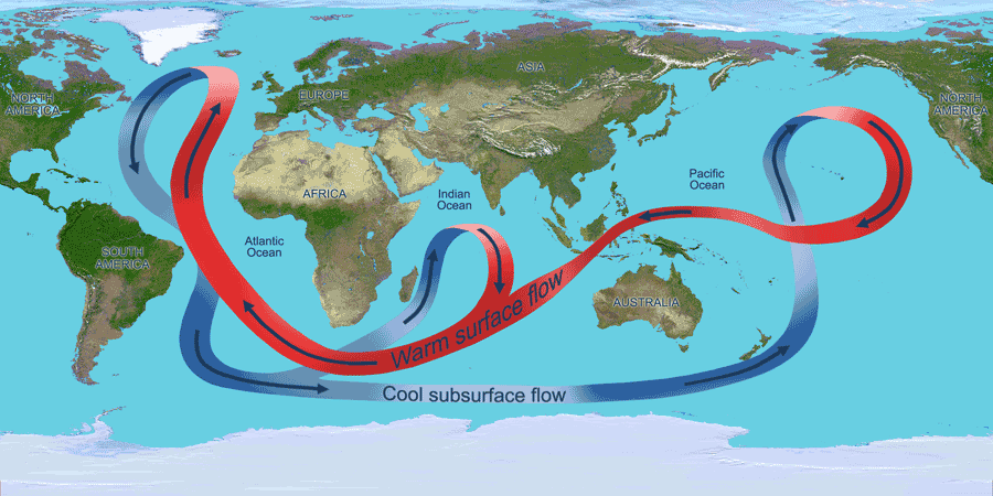 Image Credit: NASA
The surface ocean currents have a strong effect on Earth's climate. Areas near the equator receive more direct solar radiation than areas near the poles. However, these areas do not constantly get warmer and warmer, because the ocean currents and winds transport the heat from the lower latitudes near the equator to higher latitudes near the poles.
Large quantities of heat can be absorbed and stored in the surface layers of the ocean. This heat is transported by ocean currents. In this way, the ocean currents help regulate Earth's climate by facilitating the transfer of heat from warm tropical areas to colder areas near the poles.
 The water of the ocean surface moves in a regular pattern called surface ocean currents. On this map, warm currents are shown in red and cold currents are shown in blue. Image Credit: Windows to the Universe
The global wind patterns cause the surface currents to form in the uppers layer of the ocean. Where these winds blow in the same direction for long periods of time, large currents develop and transport vast amounts of water over long distances.
As these currents flow along the edges of continents, they affect the temperature of the coastal regions. Along the east coast of the U.S., the Gulf Stream carries warm water from the equatorial region to the North Atlantic Ocean, keeping the southeast coast relatively warm. Along the west coast of the U.S., the California Current carries cold water from the polar region southward, keeping the west coast relatively cooler than the east coast.
El Niño-Southern Oscillation (ENSO)
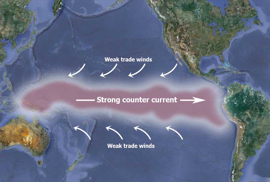 During an El Nino Southern Oscillation, the pressure over the eastern and western Pacific changes, causing the trade winds to weaken. This leads to an strong, eastward counter current of warmer waters along the equator. Map Image Source: Google Earth
The El Niño-Southern Oscillation (ENSO) is a cycle of changing wind and ocean current patterns in the Pacific Ocean. Normally, warmer water is transported westward in the Pacific Ocean by the southeast trade winds until it accumulates near Indonesia. This warm water in the western Pacific Ocean causes low air pressure and high rainfall. (Warmer water causes the air above the ocean's surface to warm and rise, leaving an area of lower pressure. More rainfall is associated with lower air pressure.)
Meanwhile, the eastern Pacific Ocean has high air pressure and less rainfall. Every 3 to 10 years, the southeast trade winds weaken, allowing the warm water to flow further eastward toward South America. Historically, this warmer current of water typically reached the western coast of South America near Christmas and became know to the Peruvian fishermen as El Niño (for the Christ child). El Niño, also known as the warm-water phase of the ENSO, causes the water temperature off of South America to be warmer and prevents the upwelling of nutrient-rich cold water. This event can have devastating effects on marine life, including coral reefs, and fisheries. An El Niño warm-water phase also changes global weather patterns. South America experiences wetter than average weather while North America experiences mild, but stormier winter weather. During an El Niño phase, there are fewer and less intense hurricanes in the Atlantic Ocean. Sometimes, after an El Niño subsides, a colder-than-normal water phase, known as La Niña, results.