Storm Events
Cyclonic storm events can be some of the most powerful storm events on the planet. A cyclone is an area of low pressure around which winds move counterclockwise in the Northern Hemisphere and clockwise in the Southern Hemisphere. The two main categories of cyclones are tropical (forming in the tropics) and extra-tropical (forming outside of the tropics).
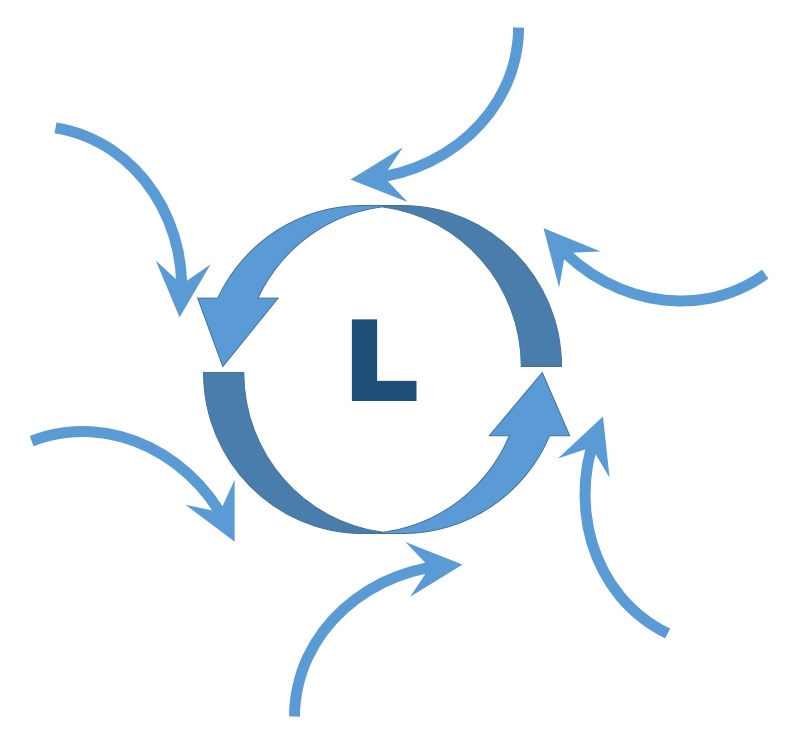 The Coriolis effect is the apparent force observed on a free-moving object in a rotating system. Earth rotates toward the east and this rotation causes fluids, such as air and currents, to be deflected to the right in the Northern Hemisphere and to the left in the Southern Hemisphere. Cyclones can form in areas of low pressure. This happens because winds, which blow from areas of high pressure to areas of low pressure, tend to blow toward the center of a low pressure area. (The Coriolis Effect causes these winds to be deflected toward the right in the Northern Hemisphere and toward the left in the Southern Hemisphere.) Therefore, these winds blowing toward the center of a low pressure system in the Northern Hemisphere do not reach the center of the system, but circulate around it in a counterclockwise direction. In the Southern Hemisphere, the winds circulate around a low pressure system in a clockwise direction.
Learn more about the Coriolis Effect:
Video Source: YoutubeHurricanes
Hurricanes, cyclones, and typhoons are all tropical cyclones. Tropical cyclones have with winds in excess of 74 miles per hour. The name––hurricane, cyclone, or typhoon––just depends on the location. Hurricanes are called typhoons in the western Pacific Ocean and cyclones in the Southern Hemisphere.
Tropical cyclones form in low pressure areas where there is warm, ocean water and low wind shear. Wind sheer is a change in speed and direction of winds at different heights in the atmosphere. Conditions are more favorable for the formation of tropical cyclones in the Northern Hemisphere than in the Southern Hemisphere. This is because the Northern Hemisphere is generally warmer. You learned that land heats more rapidly than water due to land’s lower heat capacity, and there is more landmass in the Northern Hemisphere. The Southern Hemisphere is generally cooler. There is more ocean water to warm and wind shear in the Southern Hemisphere. (Winds are stronger when there is a greater temperature difference or gradient.)
Tropical cyclones form over warm tropical waters where surface winds converge usually between 5 and 20 degrees of latitude. A tropical cyclone will strengthen as long as wind shear remains low throughout troposphere.
Tropical cyclones typically occur during “Hurricane Season,” between June 1st and November 30th.
One of the most commonly asked questions is: Will our changing climate have an impact on the frequency and intensity of hurricanes? As a result of our warming planet, we are already seeing an increase in ocean temperatures, and warmer ocean temperatures can increase the intensity of hurricanes. However, another expected result of a warmer planet is increasing wind shear, which can prevent a cyclone from forming. While the effects of these two factors are known, their combined effect is poorly understood.
In addition, The El Niño-Southern Oscillation (ENSO), a cycle of changing wind and ocean current patterns in the Pacific Ocean, affects hurricane or cyclone development. During a warm-water El Niño phase, fewer hurricanes develop in the Atlantic Ocean due to increased wind shear aloft, but more develop in the Pacific Ocean due to warmer ocean temperatures. During a cold-water La Niña phase, conditions for hurricane development are more favorable in the Atlantic Ocean.
Winter Storms
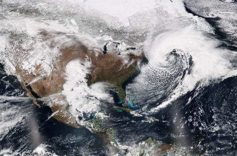
At first glance, you might think that the satellite image taken just off the northeast coast of the U.S. is of is a hurricane. However, this extra-tropical cyclone, known as a Northeaster or a Nor’easter, is one of the most severe types of winter storms. Nor’easters track along the east coast of the U.S.
The difference between hurricanes and Nor’easters has to do with where and how they form. As you learned, hurricanes form in tropical regions over warm, ocean water. Nor’easters form in the mid-latitude regions (30 to 60 degrees). They usually form over land at a frontal boundary between air masses with different temperatures and moisture. Like a hurricane, they can also intensify over the warm Gulf Stream. Nor’easters form along the east coast when there is a low temperature contrast between the land and sea, abundant moisture (supplied by the Gulf of Mexico or Atlantic Ocean), rising air and low pressure, and a mass of Arctic air just to the north or northwest. Nor’easters are named for their strong and continuous northeasterly winds that blow inland from the ocean just ahead of the storm. These winds have been known to reach hurricane strength.
Video Source: NASA
In early January 2014,the meteorological term, polar vortex, was introduced to the public. Soon, however, the term was mainstream. Everyone was talking about it and the impact across the U. S. What exactly is a polar vortex? This video, at http://www.jpl.nasa.gov/video/details.php?id=1269 , is narrated by NASA scientist Eric Fetzer using data from NASA's Atmospheric Infrared Sounder (AIRS) instrument. AIRS is an instrument that collects climate data and turns it into 3-D maps that can help improve researchers' understanding of severe weather patterns and how they relate to global climate change. The instrument was launched (along with several other instruments) aboard NASA’s Aqua satellite in 2002.