Scientists' Explanation for Exploration 2
The Retreat of Petermann Glacier
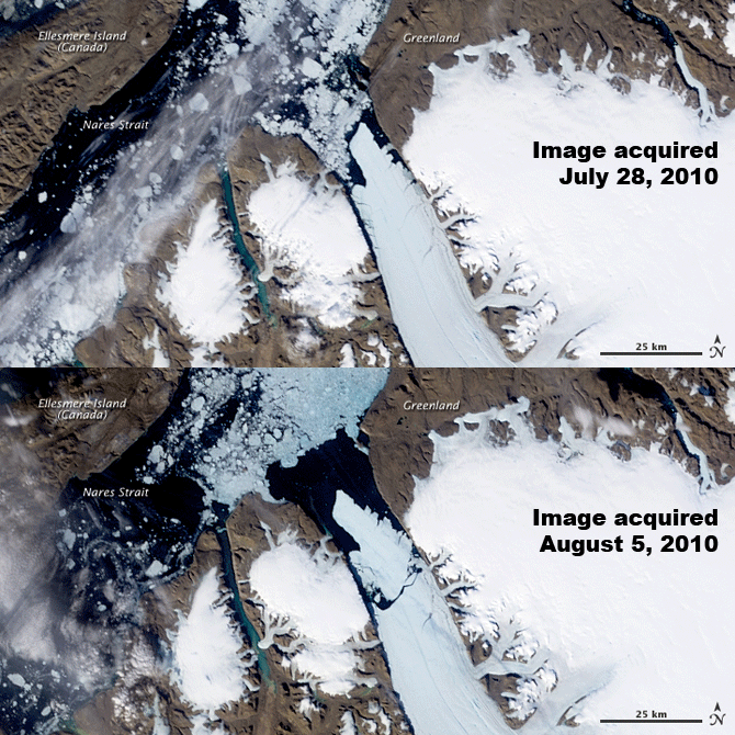
On Aug. 5, 2010, an ice island of approximately 250 km2 (100mi2) broke off of Petermann Glacier. Within hours the Canadian Ice Service detected the event as almost real-time data from NASA’s Aqua satellite via a device called MODIS (Moderate Resolution Imaging Spectroradiometer). Aqua is a polar-orbiting satellite that makes multiple passes each day over the polar regions of Earth. Below are two images of before and after the calving event. Media outlets compared the size of the island to four times the size of Manhattan!

The Petermann Glacier just before and after a calving event on August 5, 2010. Image Source:
NASA
About two years later, July 16, 2012, there was another large calving event. This time it was an area about twice the size of Manhattan measuring approximately 130 km2 (50 mi2). Since 2001, NASA scientists have been monitoring this particular crack in the glacier.
Once again, AQUA captured images of the event. Currents carried the ice island out of the outlet channel at a rate of about 1 km per day. Watch this video showing the rest of the island’s journey as it moves out of the outlet channel and into the Nares Strait. (This visualization does have one small error. Do you hear this error in the narration? Hint: You just measured the area of the ice island.)
