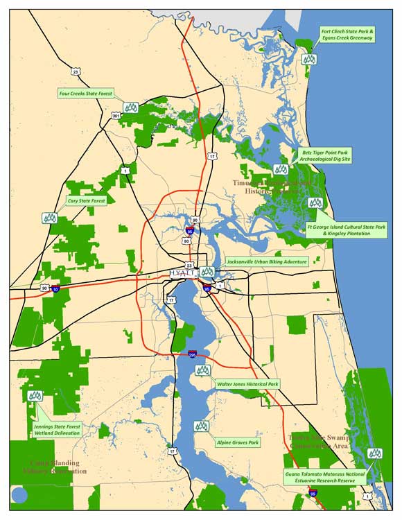
Click image for larger map - 69KB [Download High Resolution map - 318 KB ] |
Going Places!
Field Trips Wednesday, December 3 12:30 - 5:00 PM |
Betz Tiger Point Park Archaeological Site
This trip will be led by representatives from University of North Florida, Department of Environmental Protection, Division of Recreation and Parks, and the City of Jacksonville.
This trip involves an interpretive hike to an archaeological dig site near the Pumpkin Hill Creek State Preserve and will be guided by University of North Florida archaeologist Dr. Keith Ashley and staff of the City of Jacksonville.
This group will observe the sites where a team of university staff and students excavated portions of shell mounds that date from 900 AD to 1250 AD and they will be given a walk-through of how the team plots the ground, looks for likely middens, performs test digs, maps locations and finally excavates pits that are dug with almost surgical precision. Attendees will see samples of what the archaeological team uncovered from the dig sites.
Note: This trip will involve an interpretive hike on a mix of open and canopied trails and may be between 1 to 3 miles. Attendees should wear outdoor clothes and shoes and be prepared to plunge into the scrub to see how researchers seek out possible sites in the second-growth forest.

Cary and Four Creeks State Forests
This trip will be led by members of the Department of Agriculture and Consumer Services, Division of Forestry.
This group will tour by bus through Cary State Forest and observe areas under long-term restoration and timbering management by the Division of Forestry. They will learn about timbering plans; walk through natural seeding areas; observe interfaces with development, primitive camping sites, wetland restoration and increased uses by equestrians. Weather permitting the tour will also include observing an onsite prescribed burn. The tour continues to Four Creeks State Forest for a brief driving tour of this recent acquisition. Attendees will observe distinct differences with Cary State Forest due to the differing management practices over the years as Four Creeks was primarily used for industrial timbering.

Cary State Forest contains over 11,900 acres and offers the public a variety of passive, resource-based, recreational opportunities which include: hiking, primitive camping, wildlife viewing, horseback riding and hunting. The ecosystems on Cary State Forest are varied and include longleaf pine/wiregrass, mesic flatwoods, wet flatwoods, baygalls and cypress ponds. Cary State Forest is managed as a Wildlife Management Area by the Florida Fish and Wildlife Conservation Commission.
Purchased by the State of Florida in 2005 and opened to the public in July of 2008, the 13,000 acre Four Creeks State Forest in Nassau County gets its name from the fact that it has four creeks within its boundaries, and those four creeks form the head waters of the Nassau River. Primary land use prior to management by the Division of Forestry concentrated on industrial (dense planting) timbering.
Note: Attendees should wear outdoor clothes and appropriate footwear for walks along trails or forested portions of the property.
Downtown Jacksonville Urban Biking Adventure
This trip will be led by members of the City of Jacksonville Department of Recreation and Community Services and a local cycling club.
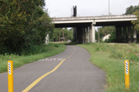
This tour will begin and end at the Jacksonville Hyatt. The initial portions will be along the Northbank Riverwalk, heading westerly through the Brooklyn district about to the Fuller Warren Bridge ultimately crossing I-95 and into the Springfield district. Once near and west of I-95, some portions of the trail will be along roadways and through the interstate mess of ramps and reconstruction, and into the neighborhoods north of I-10 and west of I-95. Some roadways are not heavily traveled while at least one does include a decent amount of traffic. Ultimately, the tour hooks back up onto sidewalks and pathways and swings by James P. Small Park and other parks containing historic features (James P. Small Park has a historic baseball stadium). The tour then runs along approximately 2 to 3 miles of recently completed paved trail occupying a former trolly line, easterly across I-95 into the Springfield Historical District, onto Henry J. Klutho Park and on by other historic features and districts (Church district and Central Civic Core district).
The City of Jacksonville is trying to develop a 10 mile urban greenway in downtown Jacksonville. And they have allies in the local bike club, which does rides on the route as a way of making sure that the cyclists stake their claim to it as users. The basis for the greenway is a mix of streets, parks and the right-of-way of a onetime electric trolley system. Part of the urban greenway system is the Northbank Riverwalk in front of the conference hotel.
Note: Experienced riders only! The trail is a work-in-progress in an urban setting, which will include riding roadways with vehicle traffic, riding through areas under construction, and navigating busy streets. Bicycles and helmets will be provided. Riders may bring their own bicycle and helmet but will be responsible for storage.

Map of Urban Bike Trail map (pdf)
Jacksonville Northbank Riverwalk - Wikipedia
Northbank Riverwalk - Jacksonville Landing
Ft. Clinch State Park & Egans Creek Greenway
This trip will be led by members of the Department of Environmental Protection, Division of Recreation and Parks; Department of Agriculture and Consumer Services, Division of Forestry; City of Fernandina Beach; The Nature Conservancy, Northeast Florida Program; Florida Fish and Wildlife Conservation Commission, Division of Habitat and Species Conservation; and the US Fish and Wildlife Service.
This group will tour historic Ft. Clinch and then learn about the invasive Redbay Ambrosia Beetle, which introduces a fungus into redbay trees, causing a fatal disease called Laurel Wilt. Then, travel through the park property to observe how management practices have kept invasive plants to a minimum.
Next, the group will drive to see adjacent private properties along the outer fringe of Ft. Clinch State Park where they will see examples of non-native invasive plants common to NE Florida and learn about developments in partnering with private landowners on controlling invasives. Then, off to walk the Egans Creek Greenway where attendees can hear from experts on the control of invasives. While touring the Egans Creek Greenway, attendees will also be led through a plant identification walking tour, which will describe an assortment of native plants and non-native invasive plants.
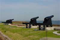
Ft. Clinch, named for General Duncan Lamont Clinch, is one in a system of permanent coastal fortifications once planned by the federal government. Construction of Forth Clinch began in 1847. Confederate forces occupied the fort briefly during the Civil War until the largest amphibious landing at that time by the United States military overtook the fort for the Union. Far from major battles of the war, soldiers' duties included fort construction. Garrisoned for only a few more years, the fort became obsolete, not able to withstand destruction by new weapons. It was placed on caretaker status in 1869. In spite of its obsolescence, Ft. Clinch was called to duty again during the Spanish-American War (1898) and was used during World War II as a communications and security post.
A part of the park system since 1935, Ft. Clinch is one of the most well-preserved 19th century forts in the country. During the 1930s, the Civilian Conservation Corps began preserving and rebuilding many of the structures of the abandoned fort. The park is named for the fortress made of almost five million bricks that guards the entrance to Cumberland Sound. Attendees will surely satisfy their taste for history and historical architecture.
The Egans Creek Greenway, located on the northern end of Amelia Island, Florida, was opened for public use in the summer of 2000 as an undeveloped park for passive recreational use. Funding for land acquisition was provided by Florida Communities Trust and the City of Fernandina Beach. It consists of over 300 acres of protected lands running north to south along Egans Creek, managed by the City of Fernandina Beach. Its grass-covered roads are suitable for walking and bicycling and its environment exhibits a variety of natural wildlife and vegetation.
Ft Clinch State Park
Egans Creek Greenway
Ft. George Island Cultural State Park & Kingsley Plantation
This trip will be led by members of the National Park Service and the Department of Environmental Protection, Division of Recreation and Parks.
This group will travel to Ft. George Island Cultural State Park in the Timucuan Ecological and Historic Preserve. Attendees will then take a guided tour of the Kingsley Plantation site and then drive to the Ribault Club. Once there, attendees will tour the building and grounds of the Ribault Club and hike along Ft. George Island's multi-use trail, along portions of the former Ribault Club golf course, onto Mount Cornelia (highest point along the coast south of North Carolina), and the Neff House, ultimately ending back at the Ribault Club.
Native Americans feasted here, colonists built a fort, and the Smart Set of the 1920s came for vacations. A site of human occupation for over 5,000 years, Fort George Island was named for a 1736 fort built to defend the southern flank of Georgia when it was a colony. Today's visitors come for boating, fishing, off-road bicycling, and hiking. Key attractions include the Kingsley Plantation and the recently restored Ribault Club.
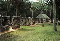
The Kingsley Plantation, administered by the National Park Service, is located on Fort George Island and includes the plantation house, a kitchen house, a barn, and the ruins of 25 of the original slave cabins. The structures at the site date to the plantation era of the island. The Kingsley Plantation was named for one of several plantation owners, Zephaniah Kingsley, who operated the property from 1813-1839.
Explore life on a nineteenth-century Florida plantation. Discover the stories of the life and times of Zephaniah Kingsley, his African wife Anna, and the hundreds of men, women, and children who were enslaved at the plantation.
The Ribault Club was established in 1928 as a playground for the affluent. The Club was marketed to wealthy Northerners and the Jacksonville elite as an early attempt to develop Florida's real estate and tourism potential. The Club faltered through the Depression and World War II. It was sold several times, used for a variety of purposes, and finally boarded up and left as a distant reminder of what once was. Recently, the Florida Park Service assembled a group of interested citizens to determine if the club was worth saving and how it could be used to best serve the community in the park setting. Interest and support rallied. Initial restoration funding began with the Florida Park Service and Historic Preservation Grants from the Florida Department of State. The project was completed through the innovative partnership between the City of Jacksonville, the National Park Service, and the Florida Park Service, now known as the Timucuan Trail State and National Parks.
This historic landmark now serves as a gateway to the Timucuan Trail, with interpretive displays and an Eastern National book store, orienting visitors to the rich 6000 year history of Fort George Island.
Note: Expect to hike approximately 1.5 miles along mostly canopied trails. Comfortable shoes and clothes are recommended.
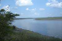
Guana Tolomato Matanzas National Estuarine Research Reserve
This trip will be led by members of the Department of Environmental Protection (DEP), Coastal and Aquatic Managed Areas (CAMA).
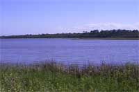
This group will take a tour of the Guana Tolomato Matanzas (GTMNERR) National Estuarine Research Reserve, one of three NERRs in Florida. Designated in 1999, the reserve, which operates through a special federal/state partnership housed within DEP, encompasses 60,000 acres of salt marsh, mangrove tidal wetlands, oyster bars, estuarine lagoons, and upland habitats. The first stop on the tour will be at the new 21,000 sq. ft. Environmental Education Center. This $6.2 million project includes interpretive exhibits, aquariums, classrooms, teaching and working laboratories, an auditorium and an outdoor amphitheater overlooking the Guana River Marsh Aquatic Preserve. Attendees will see an array of displays and hands-on exhibits designed to spark the imagination and create an understanding of the connectivity between land and sea.
After a tour of the Environmental Education Center, the group will split up and choose one of the following field sites to visit:
- Walking Tour of Upland Habitats - attendees will tour upland communities managed by CAMA and the Fish and Wildlife Conservation Commission. They will view several habitat restoration sites where recent controlled burns have been conducted, including freshwater marsh restoration and sites along A1A where mowing coastal strand vegetation has greatly reduced the hazard of burning adjacent to a residential area. The group will stop at several archeological sites and discuss the efforts underway to protect these sites from wave erosion. Recommended Attire: Outdoor clothes and appropriate footwear for walks along trails or forested portions of the property.
- Beach Exploration Field Trip - This group will see one of the longest stretches of undisturbed natural beach front on Florida's east coast- Guana Beach. Bird watchers may see shorebirds, beach comb, examine sand under a microscope, and discuss beach movement via a beach profiling demonstration. They will hear about current Reserve beach and dune conservation projects. Recommended Attire: Outdoor clothes and appropriate footwear for walking in sand.
AT GTMNERR, believing that the preservation of Florida's resources begins with an understanding of the complexities between natural systems, and the effects people have on these systems, promotes the unique opportunity for long-term research, education and interpretation. And the System-wide Monitoring Program, which tracks short-term variability and long-term changes in estuarine waters helps to create an understanding of how human activities and natural events can change ecosystems. This monitoring program provides valuable long-term data on water quality and weather at frequent time intervals.
Jennings State Forest Wetland Delineation
This trip will be led by members of the St. Johns River Water Management District, the Department of Agriculture and Consumer Services, Division of Forestry and the Department of Environmental Protection.
This group will learn wetland communities and jurisdictional wetland delineation on Jennings State Forest both in field and classroom formats. The Forest was purchased through the State of Florida's Conservation and Recreation Lands Program, Preservation 2000 Program, and the Save Our Rivers Program in cooperation with the St. John's River Water Management District. The Florida Department of Agriculture and Consumer Services, Division of Forestry has management responsibility for Jennings State Forest.
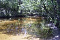
Jennings State Forest protects the headwaters of Black Creek and its tributaries. Included among the different types of natural communities at Jennings State Forest are sandhill, slope forest, flatwoods, seepage slope, dome swamp, blackwater stream, and seepage stream. Several ravines can be found in Jennings State Forest, representing the slow but never ending process of erosion by the force of water. These ravines are located along seepage streams leading to North Fork Black Creek.
Jennings State Forest is a reference site in "The Florida Wetlands Delineation Manual"
Note: Attendees should wear outdoor clothes, including waterproof footwear. Continuing education credits pending.
Jennings State Forest
The Florida Wetlands Delineation Manual
Walter Jones Historical & Alpine Groves Parks
This trip will be led by members of the City of Jacksonville Department of Recreation and Community Services.
This group will tour the grounds of Walter Jones Historical Park, including the museum and historic homestead structures, while being guided by actors that play a part from over 100 years ago. Attendees will then depart on a leisurely boat ride along the St. Johns River arriving at Alpine Groves Park where they will tour the grounds of this former citrus grove, including historic structures and farming equipment. A return trip by bus to Walter Jones Historical Park will include a windshield tour of historic homes in the Mandarin area and will include the historic post office (Walter Jones was the Postmaster) as well as a brief stop at Beluthahatchee, home to author Stetson Kennedy. Attendees will divide and exchange bus and boat trips to and from Walter Jones Historical Park.
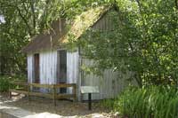
The 10-acre Walter Jones Historical Park is the essence of post-Civil War Mandarin. Walter Jones, an immigrant from England, purchased this farm along the St Johns River in about 1902 from the estate of its original owner, William W. Webb. Jones became postmaster of Mandarin and located the post office in his general store, which he and his descendants operated from 1911 to 1964. The store, which has been converted into a museum, is about a mile past the park on Mandarin Road. A new 2,500 square-foot museum opened in April 2004. It offers public educational programs, serves as a visitor center and provides artifact storage and display.
Alpine Grove Park contains 54.5 acres and is located in northwest St. Johns County along the St. Johns River and William Bartram Scenic and Historic Highway (SR13). The three historic structures located on this site were built during the nineteenth and twentieth centuries. These are the last remaining physical structures in this area, which provide a unique opportunity to learn about the rich local citrus history and economic development during the 1900's in northwest St. Johns County (Fruit Cove, Orangedale and Switzerland).
Note: Attendees should expect to get their feet wet while wading through several hundred feet of shallow water (ankle to knee deep) of the St Johns River (hard, sandy bottom) when approaching/leaving Alpine Groves Park. Comfortable shoes or sandals and clothes are recommended. You may wish to bring additional shoes/clothes to replace what may get wet.

|
|
For more information contact: Doreen DiCarlo at CES
Phone: 561-799-8553 | Fax: 561-626-1404 |E-mail: ddicarlo@ces.fau.edu |