Exploration 2
The Melting of Petermann Glacier

In the last several years, the Petermann Glacier, located in the northwestern region of Greenland, is sliding toward the sea. The glacier recently experienced two major calving events––one in August 2010 and the other in July 2012. Calving occurs when huge chunks of ice break off at the end or terminus of a glacier to form icebergs. Both of these events resulted in icebergs so large that they are referred to as ice islands.
***To print this investigation and record your responses, download this PDF document .***
In this activity, you will use Google Earth and the Polygon Tool to measure the approximate size of each of these islands.
- Download the Petermann Glacier files (source: NASA).
- Once downloaded, you can open the file in Google Earth two ways:
- Go to the location of the file and double click, OR
- Open Google Earth>File>Open and navigate to the location of your file.
- When the file is open, you should see it in your Temporary Places under Places (if you have several files already on this list, you will need to scroll down).
-
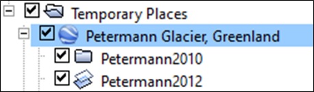 If the map is not zoomed in on the glacier, double click on Petermann Glacier, Greenland.
 - You will view ONE of these files at a time. First, uncheck the box next to the Petermann Glacier, Greenland and notice that the two files below will uncheck. Now check Petermann2010. Be patient as it may need time to load or you might have to check and uncheck a couple of times before the image will appear. The 2010 and 2012 Petermann Glaciers should appear in Google Earth as they do in the graphic below.

xxx
-
 To create a polygon to measure the area of each ice island, follow these steps. You are going to draw an outline of the ice island using the polygon tool. You may need to zoom in so that you can see the edge of the island in more detail. Click on the Add Polygon tool (on right) in the menu bar at the top of the screen. Once you click on it, a dialogue box will appear (on right).
 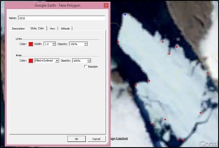 If it appears in front of the island, move it out of the way so that you can see. Next, start clicking on points around the edges of the island. Make sure that your points do not overlap. See the photo for an example. In the dialogue box, change the name to 2010 and click on the Style, Color tab, changing the color from white to something that you can see. Click OK. NOTE: YOU WILL ONLY BE ABLE TO SEE THE POLYGON THAT YOU HAVE CREATED IF YOU HIDE (UNCHECK) THE .KML FILE. UNCHECK PETERMANN 2010 IF YOU CAN’T SEE THE POLYGON.
- Repeat step 6 for the Petermann2012 layer, creating another polygon and naming it 2012. You will need to make sure that the 2010 layer is unchecked before you can start. You may choose a second color for this polygon.
- You should now have two polygons representing the ice islands. Again, if you can’t see them, uncheck the boxes next to the 2010 and 2012 layers.
-
 Determine the area in square kilometers of each polygon and fill in the table. Right click on the 2010 polygon and select copy (On a Mac, press and hold the Control (Ctrl) key while you click the mouse button.) Open this page http://www.earthpoint.us/shapes.aspx.
 - In the space under number 3, right click and paste the 2010 polygon information into the text box. You will see code pasted into the box.
- Under number 4, select degrees, square kilometers and kilometers.
- Under number 5 (Calculate the result), click View on Web Page. On the web page you should now be able to see the area in kilometers. Record the estimated area of each island in your table. Repeat for the 2012 polygon.
|
Year |
Area of Ice Islands (km2) |
|
2010 |
|
|
2012 |
|
- Use Google to determine the size of your city in km2. To do this, type in: size of . For Example, if you live in Delray Beach, type: "size of Delray Beach" in the Google search bar. The results returned should be your city in square miles and km2. If your city doesn’t show in the results, try the largest city near you. How do the 2010 and 2012 ice islands compare in size to the city where you live?