EXPLORATION 1
The Melting of Jakobshavn Glacier

The Jakobshavn Glacier, or Jakobshavn Isbræ in Danish, is located along the west coast of Greenland. For most of the 21st century, it extended out into the ocean as a long, narrow sheet of ice, known as an ice tongue. Ice tongues form when glaciers move rapidly out into the ocean. Jakobshavn Glacier is Greenland's largest outlet glacier and the fastest flowing with a surface velocity of 7 km (4.4 miles) year. Consequently, the melting of Jakobshavn Glacier has the potential to contribute to sea-level rise more than any other single feature in the Northern Hemisphere. For the last several decades, this glacier has been melting or retreating.
***To print this exploration and record your responses, download this PDF document .***
In this exploration, you will determine the rate of change (the retreating or melting) of Jakobshavn Glacier over several time periods. Using Google Earth, you will first mark the location of the retreating terminus, which is the lower-most end of the glacier, for different years. You will then measure the distance between each terminus to determine how far back the glacier has retreated. You will also calculate the rate of melting of the glacier. To begin, follow the steps below.
- Download the Jakobshavn files (source: NASA).
- Once downloaded, you can open the file in Google Earth two ways:
- Go to the location of the file and double click, OR
- Open Google Earth>File>Open and navigate to the location of your file.
-
 When the file is open, you should see it in your Temporary Places under Places (If you have several files already on this list, you will need to scroll down).
 - If the map is not zoomed in on the glacier, double click on Jakobshavn Files.
- You will view ONE of these files at a time. First, uncheck the box next to the Jakobshavn Files and notice that all files below will uncheck. Now check the 2001 glacier layer. Be patient as it may still need to load or you might have to check and uncheck a couple of times before the image will appear.
-
 To mark the terminus with a Placemark
,
follow these steps.
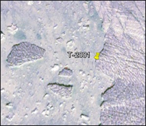
Zoom in to see the terminus of the Jakobshavn Glacier in 2001. Mark this 2001 terminus by creating a Placemark.
To mark the terminus with a Placemark
,
follow these steps.
Zoom in to see the terminus of the Jakobshavn Glacier in 2001. Mark this 2001 terminus by creating a Placemark.  To do this, select the yellow pin in the top menu bar (image on right). Once selected, a pin will appear on your map with a flashing yellow box around it, indicating that the Placemark can be moved. Move the Placemark to the terminus as seen in the picture and, in the dialogue box, name it
T-2001
. Click OK and the Placemark will be added to your map and your list on the left in Places.
To do this, select the yellow pin in the top menu bar (image on right). Once selected, a pin will appear on your map with a flashing yellow box around it, indicating that the Placemark can be moved. Move the Placemark to the terminus as seen in the picture and, in the dialogue box, name it
T-2001
. Click OK and the Placemark will be added to your map and your list on the left in Places. - Create Placemarks called T-2002 , T-2003 and T-2013 . Remember that you will need to uncheck the box next to the previously marked terminus and glacier layer files. (You may need to click on and off the selected glacier layer a couple of times for it to activate on the map.)
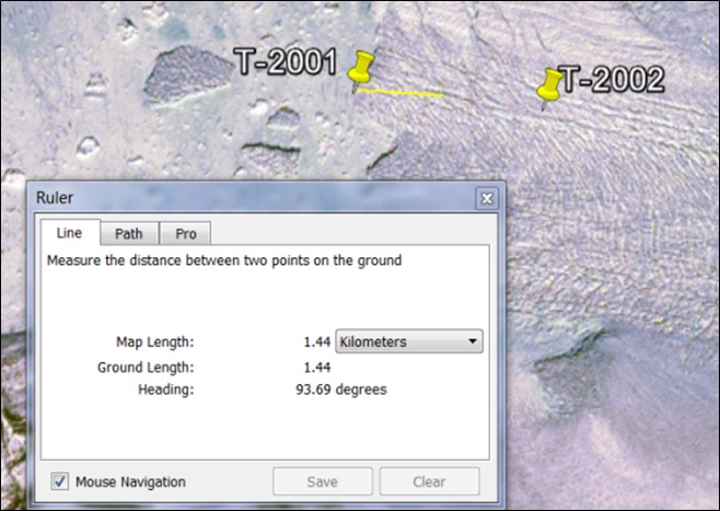
- Once you have created all four Placemarks, make sure that all Placemarks are checked (under Places) and that only the 2001 glacier layer is checked. The 2002, 2003 and 2013 glacier layers should be unchecked. Your map should appear as the one below.

-
 To
measure the distance between each terminus, follow these steps.
First, you will measure between Placemarks T-
To
measure the distance between each terminus, follow these steps.
First, you will measure between Placemarks T- 2001 and T-2002 using the Ruler tool. Once you click on it, a dialogue box will appear. If it appears in front of your Placemarks, move it out of the way so that you can see them. Click on the point of the first Placemark and then click on the second. The distance will appear in the dialogue box. Make sure that you have selected kilometers from the dropdown menu. Repeat this procedure for Placemarks T-2002 to T-2003 and T-2003 to T-2013. Record the distance for each time span in the table below.
|
Time Span |
Retreat Distance (km) |
Rate of Change/Year |
|
|
1850 |
1964 |
~60 km |
|
|
2001 |
2002 |
|
|
|
2002 |
2003 |
|
|
|
2003 |
2013 |
|
|
|
2001 |
2013 |
|
|
-
Calculate the rate of change per year for the time spans given and record this rate in the table above: retreat distance/range of years
-
Compare the retreat distance of 2002-2003 with that of 2001 -2013. What do you notice about the amount of retreat during these two time periods?
-
How does Jakobshavn Glacier’s yearly rate of retreat since 2001 compare to that before 1964?