Large global wind systems are created by the uneven heating of the Earth’s surface. These global wind systems, in turn, drive the oceans’ surface currents. To understand how global winds form and drive the major ocean currents, you need to know that wind is the basically the movement of air from an area of high pressure to an area of low pressure. Pressure is force per unit area, and air pressure is simply the weight (force) of the column of air above a particular location, per unit area. Air pressure therefore depends on elevation or altitude (higher up means less air above), the average temperature of the air above the particular location (hot air is lighter than cold air), and what the air's composition is. For example, air with a large amount of water vapor is less dense than dry air because the water molecule has less mass than either an individual nitrogen or oxygen molecule. Also as elevation or altitude increases, air becomes less dense.
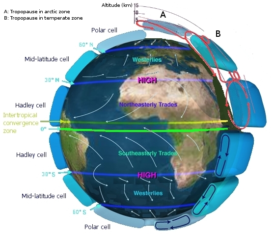
Unequal heating of the Earth’s surface also forms large global wind patterns. In area near the equator, the sun is almost directly overhead for most of the year. Warm air rises at the equator and moves toward the poles. At the poles, the cooler air sinks and moves back toward the equator. However, it is not this simple. Global winds do not move directly from north to south or south to north because the Earth rotates. All winds in the Northern Hemisphere appear to curve to right as they move. In the southern hemisphere, winds appear to curve to the left. This is known as the Coriolis effect, which is the apparent shift in the path of any fluid or object moving about the surface of the Earth due to the rotation of the Earth.
Near the equator, the trade winds converge into a broad east to west area of light winds. The area is known as the doldrums because there are light winds. This belt of air around the equator receives much of the sun’s radiant energy. This area is known as the intertropical convergence zone (ITCZ), and is the area with the most active weather. The latitude where Earth’s mean annual surface temperature is highest is located at 10°N. As you learned the Northern Hemisphere has more landmass and is relatively warmer than the Southern Hemisphere. Also at the equator, warmer, moist air rises and produces a low-pressure area extending many kilometers north and south of the equator.
Trade Winds – About 30° north and south of the equator, the warm, moist air that rose vertically cools and begins to sink. Here the sky is clear. There are few clouds and little rainfall. Winds are calm. These are called the horse latitudes, because when food ran out, sailors had to throw horses overboard. Deserts, such as the Sahara in Africa, are also common at 30°N and 30°S. At the horse latitudes some of the sinking air travels back toward the equator. The air moving back toward the equator forms warm, steady winds, known as the trade winds.
The rising air at the equatorial regions and the sinking air at about 30°N and 30°S form huge convection current, known as a Hadley cell for the English meteorologist who first proposed their existence to explain the trade winds.
Prevailing Westerlies – Some of the cool, sinking air continues to move toward the North and South. These winds are called the westerlies and are located between 40°to 60° latitude in both hemispheres.
Polar Easterlies – In both hemispheres, the westerlies start rising and cooling between 50° and 60° latitude as they approach the poles. They meet extremely cold air flowing toward the equator from the poles and form the polar easterlies.